
Introduction
When people look at offshore wind farms or mega-ports, they often see only the towering turbines, the container cranes, or the endless flow of trade. What most miss is that beneath all the visible infrastructure lies an invisible foundation: the seabed knowledge that made it possible.
That invisible foundation is the work of hydrographic surveys. These highly technical studies map, measure, and monitor the seafloor, ensuring that projects worth billions are built safely, efficiently, and sustainably. Without them, turbines would topple, cables would snap, and mega-ships would run aground.
In 2025, as offshore wind accelerates and ports expand to handle the world’s largest vessels, hydrographic surveying is no longer a supporting role — it is the backbone of modern offshore engineering.
👉 At Nautrex, we connect you with trusted experts in Oceanographic & Hydrographic Surveying who make these critical foundations possible.
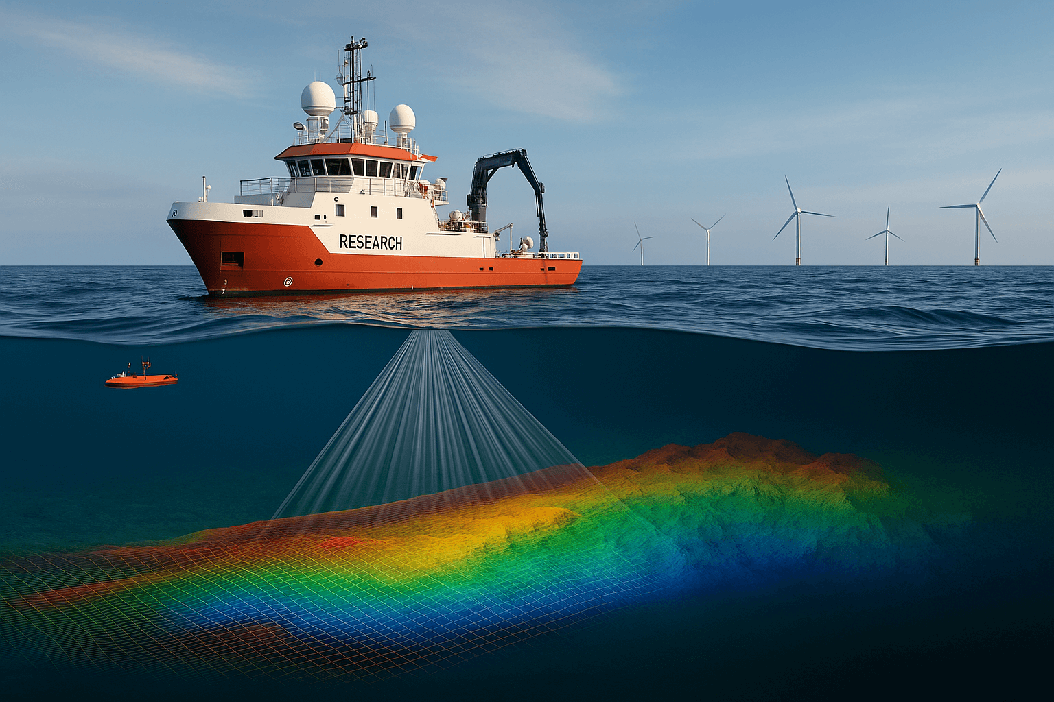
What Are Hydrographic Surveys?
Mapping the Ocean Floor
Hydrographic surveys are the science of measuring and describing the physical features of oceans, seas, and coastal areas. Think of it as creating a blueprint of the seafloor — detailing depths, contours, sediment types, and hazards.
For centuries, these surveys were basic depth soundings. Today, they are high-resolution 3D models that capture every ridge, slope, and object on the seabed with centimeter precision.
Tools of the Trade
The technology is as impressive as the outcomes:
- Multibeam Sonar: Produces wide swaths of detailed seabed imagery.
- LiDAR (Laser Scanning): Used in shallow coastal zones for ultra-precise mapping.
- AUVs (Autonomous Underwater Vehicles): Glide silently, capturing data in deep or hazardous waters.
- USVs (Uncrewed Surface Vessels): Compact survey boats that can operate autonomously for long durations.
Together, these tools build the data foundation on which billion-dollar decisions rest.
Offshore Wind’s Dependence on Surveys
Turbine Placement & Foundation Stability
Offshore turbines are engineering giants, often standing over 200 meters tall. For them to stand firm in storms, their foundations must be anchored into seabeds that have been meticulously studied. Hydrographic surveys determine soil types, bedrock depth, and sediment stability — factors that dictate whether a monopile, jacket, or floating foundation is viable.
Subsea Cable Routing
Every offshore wind farm requires kilometers of subsea cables to connect turbines and transmit power to shore. Poorly planned routes risk damage from currents, fishing activity, or seabed shifts. Surveys identify the safest, most stable pathways for cable burial, reducing maintenance costs and extending system life.
Monitoring Scour & Sediment Shift
Even after turbines are installed, the seabed never rests. Currents can cause scour — erosion around foundations — threatening stability. Hydrographic surveys provide continuous monitoring, ensuring early detection and intervention.
Without accurate hydrographic data, offshore wind farms would face catastrophic risks. With it, they become reliable energy producers for decades.
Why Port Expansion Depends on Surveys
Dredging & Channel Design
Modern mega-ships, like container vessels carrying over 24,000 TEUs, demand channels and berths deeper than ever before. Hydrographic surveys provide the precision needed for dredging operations — ensuring channels are deep enough, yet stable and environmentally compliant.
Berth Deepening & Ship Size Trends
As vessels grow larger, ports must constantly adapt. Surveys help engineers design berths that can accommodate future classes of ships, not just today’s. This future-proofing is vital for ports investing billions in expansion.
Navigation Safety & Compliance
Hydrographic surveys also serve the most fundamental purpose: safety. Accurate charts prevent collisions and groundings, giving captains and pilots confidence as they maneuver massive vessels into tight spaces.
A port may boast cranes, logistics parks, and automation, but none of it functions without the seabed maps that guide ships safely in.
Tech Transforming Hydrographic Surveying in 2025
Multibeam Sonar Precision
Today’s multibeam sonar systems can map swaths of seabed hundreds of meters wide in a single pass. The resulting images are so detailed they can pick out individual cables, wrecks, or small debris — essential for both safety and planning.
Autonomous AUVs & USVs
The rise of autonomous fleets has revolutionized surveying. AUVs dive deep, scanning areas beyond human reach. USVs, often the size of small cars, can operate for weeks without crew, reducing costs and risks while covering more ground.
AI and Digital Twin Modeling
Artificial intelligence now processes terabytes of survey data in real time. Combined with digital twins, ports and offshore operators can model scenarios — from dredging effects to storm surges — ensuring smarter, faster decisions.
Hydrographic surveying in 2025 is as much about data science as it is about seafloor mapping.
The Costs of Neglecting Surveys
Delays & Redesigns
Skipping or rushing surveys can doom projects. Foundations may fail, channels may require unexpected dredging, and entire cable routes may need re-engineering. Delays of even a few months can mean hundreds of millions in extra costs.
Grounding & Accidents
Some of the world’s most costly maritime accidents have roots in poor hydrographic knowledge. A ship grounding in a port not only damages the vessel but can shut down operations, disrupt trade, and create massive legal liabilities.
Insurance & Regulatory Penalties
Insurers and regulators demand hydrographic data before approving projects. Without it, financing dries up and approvals stall. A weak survey record can lead to skyrocketing insurance premiums or outright rejection of coverage.
The Future of Hydrographic Surveys
Swarm Robotics
The next wave of surveying will involve fleets of small AUVs and USVs working in coordination — covering vast areas in record time. These “swarms” will create near real-time seabed maps.
Real-Time AI Analysis
Instead of waiting weeks for data processing, future surveys will be interpreted instantly. AI will flag risks and anomalies in real time, helping engineers make decisions on the spot.
Coastal Resilience & Climate Planning
As climate change drives sea level rise and more extreme storms, hydrographic surveys will be central to coastal defense strategies. From flood barriers to resilient ports, the data will guide how humanity adapts to shifting seas.
How Nautrex Connects You With Survey Experts
At Nautrex, we know that offshore projects and port expansions live or die by the quality of their hydrographic data.
Through our Oceanographic & Hydrographic Surveying category, you can connect with:
- Certified hydrographic survey firms.
- Experts in AUV, USV, and multibeam operations.
- Specialists in offshore wind and port-specific surveying.
Whether you’re building a next-generation offshore wind farm or planning a port expansion that will redefine trade flows, Nautrex ensures you have the seabed intelligence to succeed.
Conclusion
Hydrographic surveys rarely make headlines. They’re invisible, quiet, and often overlooked. Yet, they are the unsung heroes of offshore engineering — the maps and models that turn blueprints into billion-dollar realities.
In offshore wind, they anchor our renewable future. In ports, they ensure global trade never stops. And in both, they protect investments, ecosystems, and lives.
The truth is simple: without hydrographic surveys, there is no offshore progress. With them, we can build a safer, smarter, and more sustainable maritime world.
👉 Explore how Nautrex connects you to the experts shaping this future at Nautrex.